We believe in results, strong relationships, and lasting impact.
Services
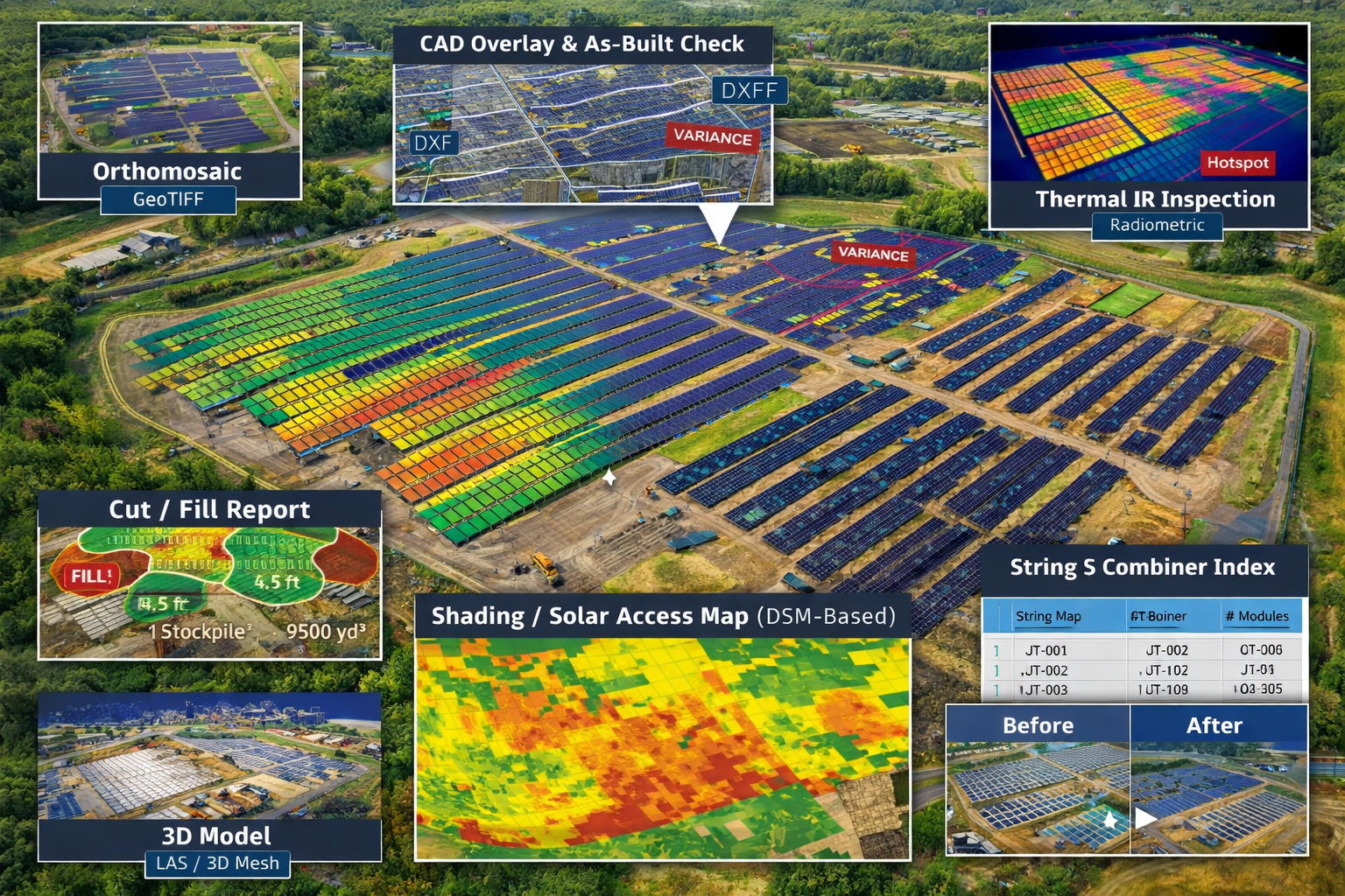
Solar Mapping & Inspection
SkyBlue Aerials provides fast, site-accurate drone mapping and inspection for utility-scale and commercial solar projects. We deliver clean, actionable outputs your engineering, construction, and O&M teams can use immediately—no special software required.
Core Mapping
We produce a georeferenced orthomosaic (GeoTIFF), digital surface model (DSM), and contours aligned to your site. These layers create a reliable visual and elevation baseline for planning, progress coordination, and documentation. Where feasible, we can also provide a DTM (bare-earth) for drainage and grading checks.
Shading & Solar Access
Using the DSM, we generate shading/solar-access maps that model sun-angle impacts on rows, equipment pads, and obstacles. These outputs help with layout refinements, performance risk reviews, and production planning.
String & Combiner Mapping
From your design files, we label strings and combiner locations directly on the orthomosaic and deliver a companion CSV index. The result is an easy-to-audit field reference for commissioning, QA, and future maintenance.
CAD Overlay & As-Built Checks
We overlay your CAD on the current map to highlight deviations as the site is built. A concise as-built check map with deltas and notes makes it simple to review placement, spacing, and alignment during inspections or handover.
3D Assets
For model-based coordination, we package a 3D point cloud (LAS/LAZ) and a 3D mesh (OBJ/PLY) so engineers and VDC teams can take measurements and visualize the site without extra conversion steps.
Earthwork & Materials
When quantities matter, we provide cut/fill reports across defined areas and stockpile volumes with labeled polygons and a CSV table. These deliverables support pay apps, procurement, and schedule reviews.
Progress Packages
Keep stakeholders aligned with a predictable cadence:
Scout – one visit per month (≤30 acres): Ortho + DSM + Contours.
Tracker – two visits per month (≤50 acres): adds change maps vs. last visit.
SkyBlue Horizon – four visits per month (≤80 acres): adds a QA summary for each set.
(We’ll brand the middle tier with your preferred name—e.g., Vector, Waypoint, or Flightpath.)
QA / Control
Add a Control / QA Report when you need documented checks alongside deliverables. This summary accompanies your files and supports internal reviews and owner updates.
Thermal IR (Optional, Partnered)
When thermal is requested, we coordinate a module-level IR inspection via our partner workflow and deliver anomaly maps and tables (e.g., hotspots, open strings) per MW.
What You Receive
Every engagement includes a clean one-page PDF overview, map layers for your records, and open formats for your tools: GeoTIFF, SHP/GeoJSON, DXF, LAS/LAZ, OBJ/PLY, CSV, PDF, and GeoPDF (phone-ready, offline). Travel and setup are itemized for transparent scope; turnaround is typically 48–72 hours after flight, with rush options available.
What Sets Us Apart
People-First Approach
Everything we do is built around understanding your needs and helping you succeed—because when you thrive, so do we.
Long-Term Relationships
We’re not just here for the now. We love creating lasting relationships with our clients and growing with them over time.
Proven Process, Flexible Execution
We bring structure where it counts and adaptability where it matters. Our methods are clear, but always responsive.